NASA's AREN Project
![]()
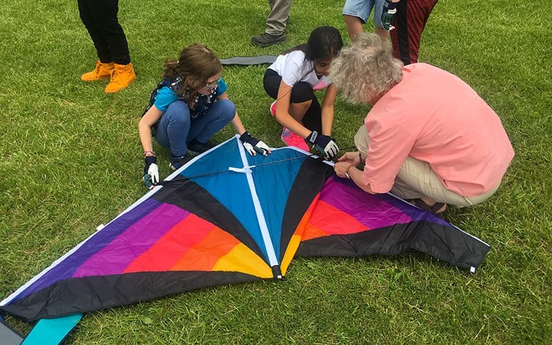
AEROKATS and ROVER Education Network
The AEROKATS and ROVER Education Network (AREN), funded through NASA’s Science Activation program (NASA CAN Award #NNX16AB95A), is training the next generation of scientists, engineers, and other professionals to observe and understand our planet Earth.
Through hands-on, place-based learning, AREN brings NASA technology and real-world data into classrooms and communities. Participants explore Earth science in action—flying kites equipped with sensors, analyzing environmental data, and applying cutting-edge tools—to build skills that inspire curiosity and prepare them for future STEM careers.
- AEROKATS (Advancing Earth Research Observations with Kites and Atmospheric/Terrestrial Sensors). AEROKATS focuses on the use of kite-borne remote sensing and in situ atmospheric sensor systems (Aeropods) for Earth-systems observation and research.
- ROVER (Remotely Operated Vehicle for Environmental Research). Utilizes land- and water-based remotely controlled sensor platforms to collect environmental and Earth-systems data for research and classroom investigations.
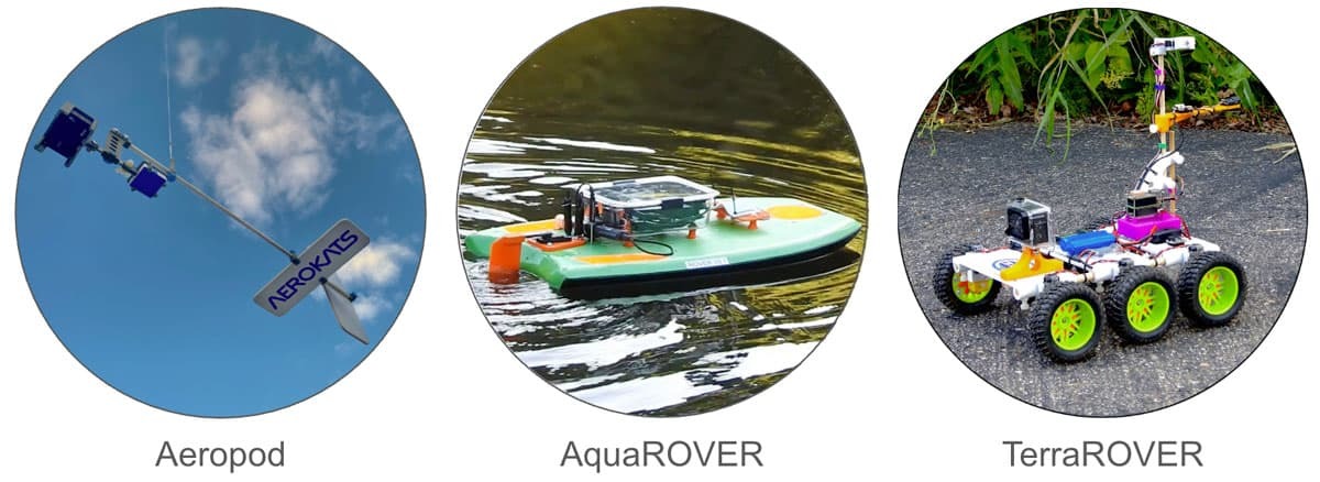
The AREN project engages students and educators in hands-on Earth science research using innovative, low-cost NASA technologies:
- Aeropods - kite-borne, aerodynamically stabilized sensor platforms
- AquaROVERs - remotely controlled, sensor-equipped aquatic vehicles
- TerraROVERs - remotely controlled, sensor-equipped terrestrial vehicles
Learners gain hands-on experience in safely operating AREN systems while collecting and analyzing real environmental data. These technologies, along with operations concepts—such as safety, teamwork, communication, and procedures—and NGSS-aligned activities, are designed to engage learners from a wide range of backgrounds and age levels.
To expand learning opportunities, AREN partners with NASA’s GLOBE Program (Global Learning and Observations to Benefit the Environment) and other NASA Science Activation projects, offering additional resources and opportunities for collaboration.
Objectives
- Develop approaches, learning plans, and specific tools suitable for middle school through undergraduate education that can be affordably implemented nationwide.
- Introduce and implement new NASA concepts and technologies in a variety of educational and community science settings for a diverse audience.
- Provide tools and activities that engage educators, students, and communities in STEM disciplines.
Additionally, the AREN project addresses four of NASA’s Science Activation Mid-Level Objectives (MLOs):
- MLO 1a: Inspire participants’ interest in STEM and the development of their identities as science learners.
- MLO 3b: Increase the diversity of participants reached by Science Activation through intentional, inclusive programming.
- MLO 3c: Engage participants in learning experiences that promote development of skills for STEM careers.
- MLO 4b: Utilize external partners to leverage reach and effectiveness of the Science Activation portfolio.
AEROKATS and ROVER Education Network (AREN) Model
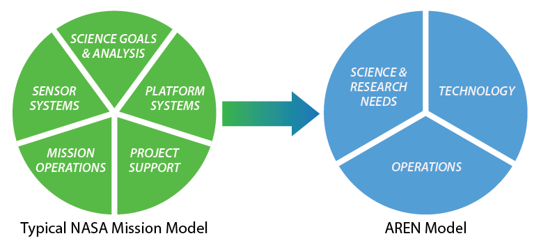
The AREN model is distilled from a typical NASA Mission Model for use in a broader educational and research environment. Notably, Sensor Systems and Platform Systems have been combined into Technology, and Mission Operations and Project Support have been grouped into the broader category of Operations.
Team and Participating Institutions/Organizations
The AREN Project is a collaborative effort led by Wayne RESA and the NASA Goddard Space Flight Center, along with several partner institutions, including colleges, universities, non-profit organizations, and commercial partners. AREN also collaborates with several other national organizations and non-profits and is a GLOBE Program partner. (insert link to GLOBE).
Listing of AREN Project Team Institutions:
- Wayne RESA (Lead Institution)
- Goddard Space Flight Center
- Anasphere, Inc.
- Black Swift Technologies (BST)
- Chesapeake Bay Environmental Center
- Drexel University
- Montana State University
- Oklahoma State University
- State University of New York - Fredonia
- The Public Laboratory for Open Science and Technology
- University of Alaska Fairbanks
- University of Colorado – Boulder
- University of Maryland Eastern Shore
- University of South Florida
- Washington College
Science Activation Collaborations:
- GLOBE Mission Earth
- Arctic Earth and Signs
- Challenger Learning Center
- Northwest Earth and Space Sciences (NESSP)
- Smoky Mountains STEM Collaborative
External Collaborative partnerships include:
- AmericaView
- American Kitefliers Assoc. (AKA)
- National Park Service (NPS)
- Great Winds Kites
- Into The Wind
- Young Elites of the Eastern Shore West to East Coast Aviation Network (YEESWECAN, Maryland/Virginia)
- Rouge Education Project (Michigan)
- Montana Learning Center
- Pisgah Astronomical Research Institute (PARI, North Carolina)
- Howard B. Owens Science Center (Maryland)
- SABENS Group
- Legacy Bridges STEM Academy
- Puerto Rico School System
History of the AREN Project
2010-2013: Wayne RESA, Eastern Michigan University, and NASA GSFC/Wallops Flight Facility combine to pilot Investigating Climate Change and Remote Sensing (ICCARS Project) (NASA CAN Award #NNX10AD30A). Students in the greater Detroit metropolitan area begin using NASA Aeropods to study local environments.
2012: NASA patents the Aeropod platform for kite-borne sensors.
2015: NASA develops an educational evaluation license for Aeropod technology. Wayne RESA secures a license for future use.
2015: NASA awards CAN # NNX16AB95A to fund the AEROKATS and ROVER Education Network (aka AREN Project) for five years; ICCARS scales into AREN under Wayne RESA and GSFC/Wallops Flight Facility leadership with multiple national partners.
2016–2020: AREN develops materials and programming and conducts training and program activities for K-12 educators and students, universities, citizen scientists, and the general public.
2020: NASA extends awards CAN # NNX16AB95A for an additional five-year period of performance
2020: COVID pandemic forces a pivot of activities to a remote, largely online environment. The AREN team recalibrates its approach to training and moves forward as COVID restrictions ease.
2021: The TerraROVER platform is developed at GSFC/WFF. The Urban Heat Island Instrumentation Package (UHIP) for the TerraROVER is developed at Wayne RESA.
2022: First deployment of TerraROVER and UHIP to audiences on a nationwide scale.
2025: AREN reaches the end of the second five-year period of performance. A No-cost extension of one year is secured to spend down remaining funds on sustainability efforts.
Wayne RESA AREN Project Contacts
AREN Mission Mapper
The Mission Mapper is a web-based mapping tool where AREN participants can upload and share mission metadata, images, and datasets collected from Aeropod and TerraROVER missions.
AREN Opportunities & Training Materials
AREN Opportunities
AEROKATS Operations/Training Materials
 AREN Flight Operations Field Manual
 This manual contains procedures and practices for safely conducting AREN AEROKATS missions. Included are procedures for preparation, safety, team assignments, mission data and recording, launching and landing kites and aeropods, checklists, kite and line setup, Aeropod assembly and more. Operational procedures are key to success in AREN missions. This manual will help you be successful and stay safe while having fun collecting data from kite-based systems!
TerraROVER Training Materials
 TerraROVER 2025 Model Documentation
 This zip file contains the full set of operational documents for the 2025 model of TerraROVER. This production model of the TerraROVER was delivered to the September 2025 “Exploring Surface Temperature with an AREN TerraROVER” workshop participants. This model included the Arduino Feather based UHIP(v2), dual light sensors, and introduced the AKASO v50 X camera and rubber wheels.
 TerraROVER 2024 Model Documentation
 This zip file contains the full set of operational documents for the 2024 model of TerraROVER. This production model of the TerraROVER was delivered to the MAy 2024 “Exploring Surface Temperature with an AREN TerraROVER” workshop participants. This model included the Arduino Feather based UHIP(v2) and a single light sensor.
 TerraROVER 2023 Model Documentation
 This zip file contains the full set of operational documents for the 2023 model of TerraROVER. This production model of the TerraROVER was delivered to the MAy 2023 “Exploring Surface Temperature with an AREN TerraROVER “ workshop participants. This model introduced the Arduino Feather based UHIP(v2) and a single light sensor.
 TerraROVER 2022 Model Documentation
 This zip file contains the full set of operational documents for the 2022 model of TerraROVER. This was the first production model of the TerraROVER, and was delivered to the May 2022 “Exploring Surface Temperature with an AREN TerraROVER “ workshop participants. This was the only year that included the Arduino Leonardo Board based UHIP(v1). Later models were equipped with the Adafruit Feather based UHIP.
AREN Past Participant Training Materials
Key Technologies
AEROKATS
![]()
AEROKATS – (Advancing Earth Research Observations with Kites and Atmospheric/Terrestrial Sensors)
Aeropod: Aerodynamically stabilized instrument platform
The Aeropod is a NASA-designed, low-altitude remote sensing platform designed for environmental research purposes. The Aeropod is a passive device that uses aerodynamic forces to stabilize an instrument package suspended from a kite or tethered balloon. Aeropods can be used for a variety of remote sensing and remotely captured in-situ (in place) observations.
Benefits:
- Lightweight, simple to construct, and has no moving parts.
- Useful for a variety of remote sensing and in-situ observations.
- Able to accommodate many different-sized instruments.
- Offers a low-cost alternative to other remote sensing and observation techniques.
The basic Aeropod design consists of a payload, a boom, fins for dampening motion, and a pylon to suspend the Aeropod from a kite line.
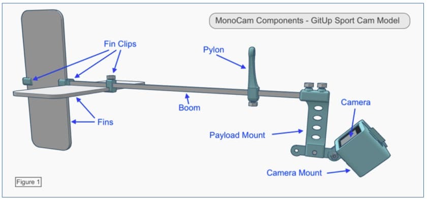
A technical diagram showing MonoCam components for the GitUp Sport Cam model. It includes a horizontal boom with fins attached on the left using fin clips, a vertical pylon near the center, and a payload mount on the right holding a camera mount and tilted camera. Labels point to each part: Fin Clips, Fins, Boom, Pylon, Payload Mount, Camera Mount, and Camera.
Aeropods can be designed with a variety of payloads to address myriad research interests. They have been used to monitor crops and agriculture, land cover and land use, invasive species, volcanic gases, conduct atmospheric profiles, and much more.
In the AREN project, they are largely used for capturing aerial imagery for monitoring land cover and land use, invasive species, vegetation monitoring, and atmospheric profiling.
Examples of the most commonly used Aeropods in the AREN project include:
MiniCam Aeropod
A lightweight, introductory aerial imaging system using a small spy camera. This is a good option for novices and can be used with smaller kites than other Aeropods. 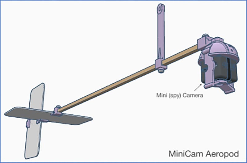
A technical diagram of the MiniCam Aeropod. It features a horizontal boom with fins attached at the left end and a vertical support near the center. On the right end, a camera is mounted using a bracket labeled ‘MiniCam Camera.’ The design shows a streamlined structure for aerial mounting.
MonoCam Aeropod
An aerial imaging system using a sports camera (similar to a GoPro). This system provides higher-quality imagery than the MiniCam but also requires a larger kite.
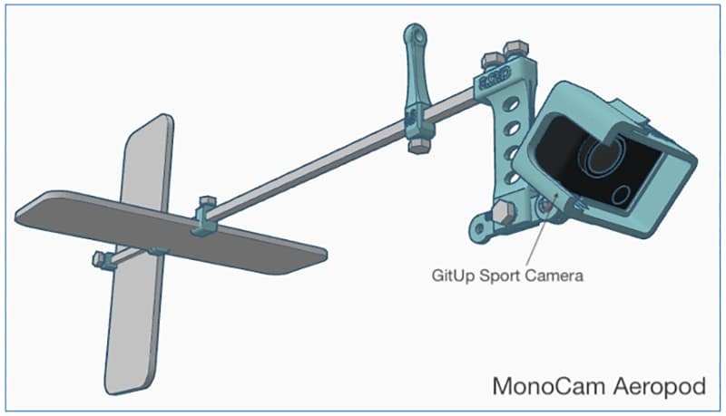
A technical diagram of the MonoCam Aeropod. It features a horizontal boom with fins attached at the left end and a vertical pylon near the center. On the right end, a GitUp Sport Camera is mounted on a bracket with multiple holes for adjustment. The design illustrates a streamlined aerial mounting system.
TwinCam Aeropod
A multispectral imaging system that uses two cameras to collect both visible and near-infrared imagery. The imagery can be combined in software to produce estimates of photosynthetically active vegetation, classified land cover images, and more. This system is for more advanced users and requires a large kite for lift.
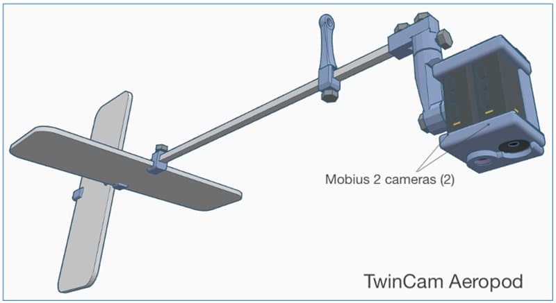
A technical diagram of the TwinCam Aeropod. It features a horizontal boom with fins attached at the left end and a vertical pylon near the center. On the right end, two Mobius cameras are mounted on a bracket labeled ‘Mobius 2 cameras (2).’ The design illustrates a dual-camera aerial mounting system for capturing multiple angles.
There are many other Aeropod designs ranging from entry-level use to advanced research platforms.
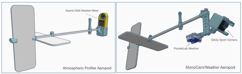
The image shows two technical diagrams side by side. The left diagram is labeled ‘Atmospheric Profiler Aeropod’ and features a horizontal boom with fins on the left end and a Kestrel 5500 Weather Meter mounted on the right end near a vertical pylon. The right diagram is labeled ‘MonoCam/Weather Aeropod’ and includes a similar boom with fins on the left, a vertical pylon near the center, and a GitUp Sport Camera mounted on the right end along with a PocketLab Weather sensor beneath the boom. Both designs illustrate aerial mounting systems for weather and camera instrumentation.
Please note: The Aeropod is a patented NASA technology (Patent # US 8,196,853 B2) and requires a license to use or make. Participants in AREN workshops are included in the AREN Project license. Individuals who would like to make or use Aeropods on their own can apply for a free evaluation license at: https://technology.nasa.gov/patent/GSC-TOPS-10
The AREN Project trains participants to safely conduct Aeropod missions and to process and analyze the data they collect. A variety of data analysis tools are employed to address a wide range of skill levels from upper elementary through university-level research.
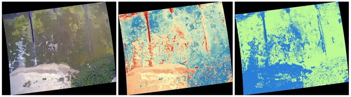
Examples of Aeropod data products
Examples of Aeropod data products
Green Leaf Index created with MonoCam Aeropod imagery and QGIS software
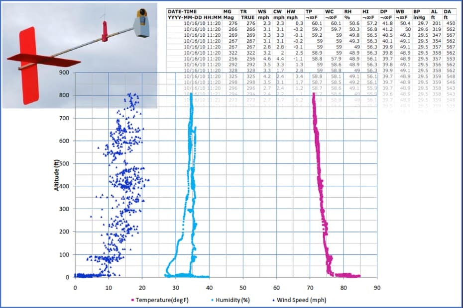
Atmospheric Boundary Layer Profile using Profiler Aeropod data and MS Excel software
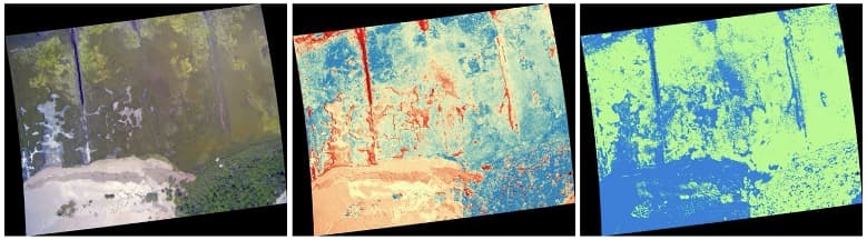
Twin Cam Image Processing - Classification Example
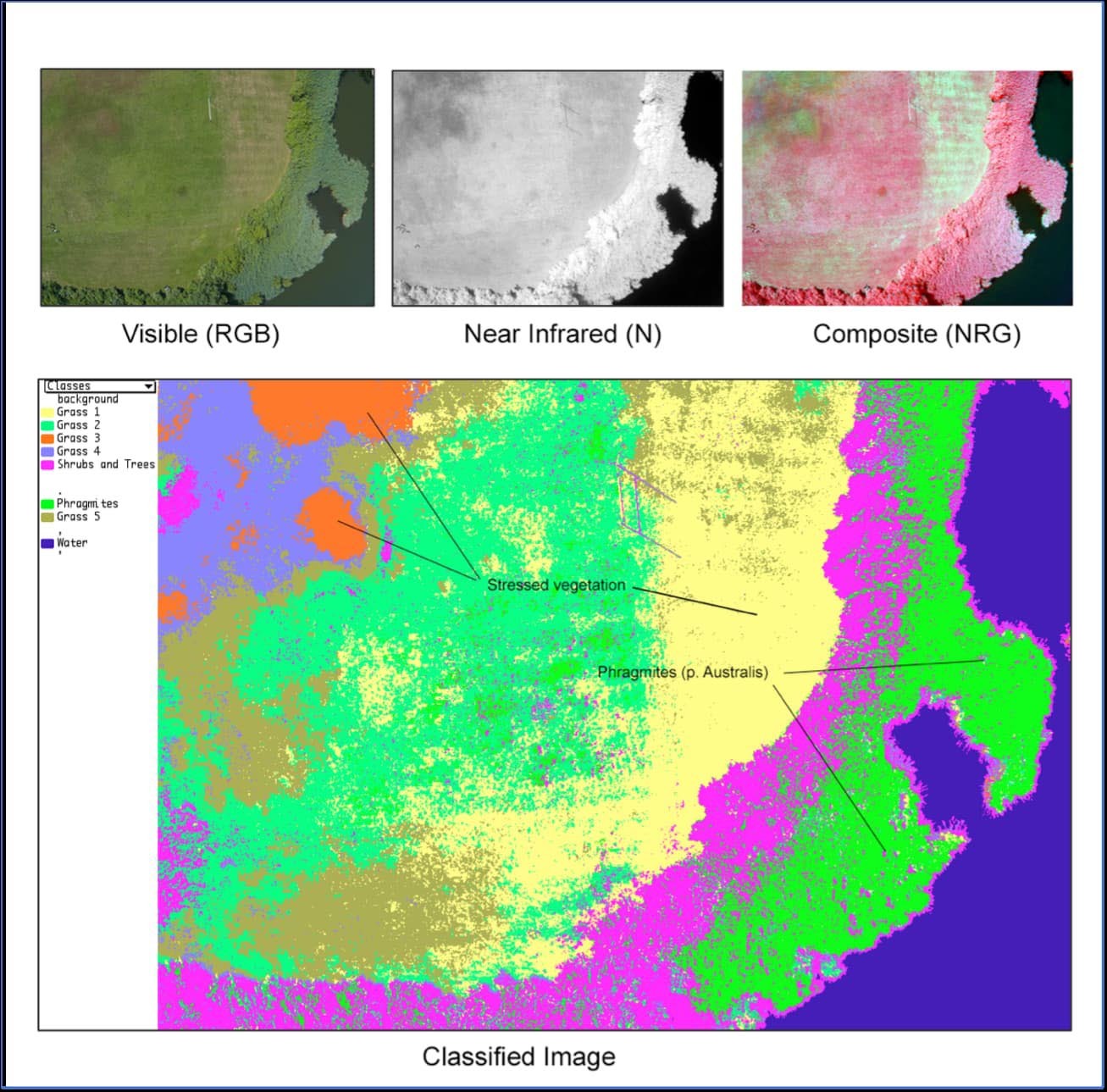
Invasive Species Detection using TwinCam imagery and MultiSpec software.
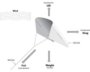
KITES and Tethered Balloons
Aeropods are designed to be carried aloft by kites or tethered balloons. Individuals with experience using tethered balloons and blimps have used Aeropods for research purposes. These are often professionals or researchers in university settings. For the AREN Project, the focus has largely been on kite-based systems for simplicity and reaching a broad audience.
Aeropod performance is best in light to moderate winds. Large (7 – 9 ft wingspan) Delta and Delta-Conyne style kites are ideal for lifting in light winds. As a result, those are the primary kite styles employed in the AREN Project. For moderate winds, large parafoil-style kites can also perform well. The AREN Project also uses small sled-style kites called Frustrationless Flyers for training.
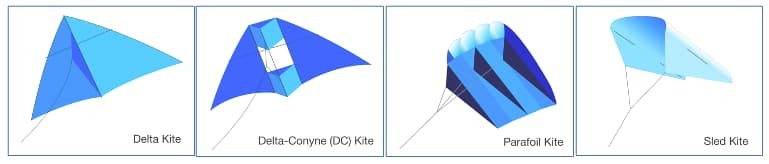
AREN partners with Into the Wind to provide kites for the project. The kites most utilized for carrying Aeropods in the AREN Project have been:
- ITW 7ft Levitation Lite (A delta kite for lifting smaller Aeropods in light to moderate winds)
- ITW 9ft Levitation Lite (A delta kite for lifting larger Aeropods in light winds)
- ITW 10ft Alpine DC (A delta-conyne kite for lifting larger Aeropods in light winds)
- ITW 10ft Parafoil (A parafoil kite for lifting larger Aeropods in moderate winds)
- Frustrationless Flyers (A small sled kite that can be built and decorated by students. Used for training)
Kites from other manufacturers and in other styles can be used as well, and experimentation is welcome!
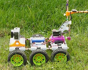
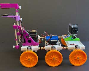
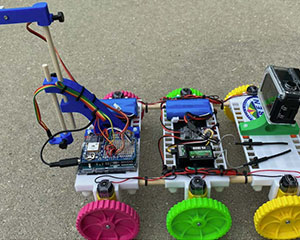
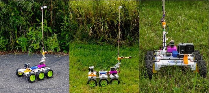
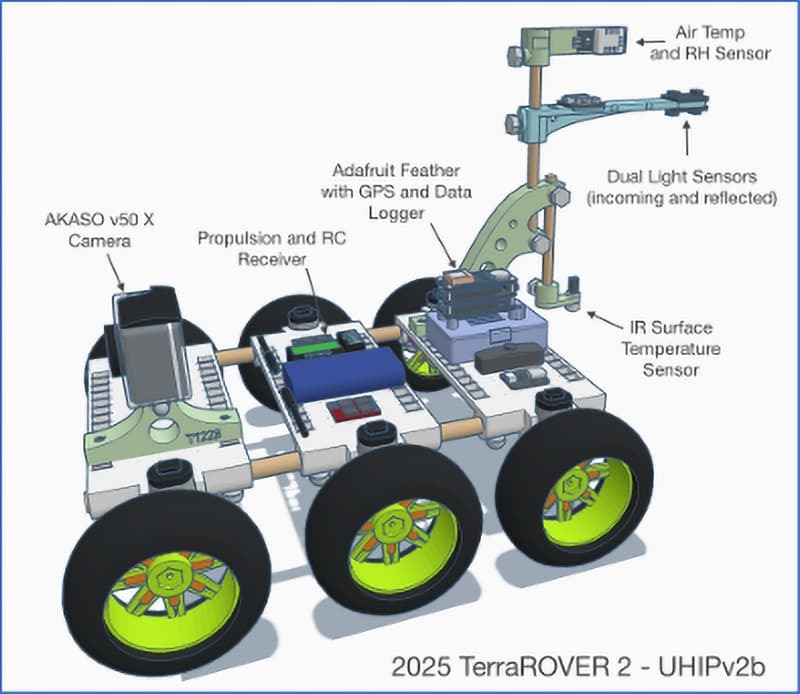
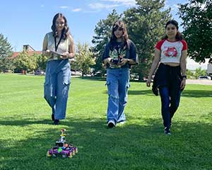
TerraROVERs
![]()
ROVER (Remotely Operated Vehicle for Environmental Research)
ROVER (Remotely Operated Vehicle for Environmental Research)
ROVERs extend AREN’s experiential learning by allowing remotely collected measurements of environmental phenomena in terrestrial (TerraROVER) and aquatic (AquaROVER) environments. For TerraROVERs, these include surface and air temperature, relative humidity, albedo, aerosols, and more. AquaROVERs are used to gather water quality data, such as temperature, pH, dissolved oxygen, salinity, and additional parameters.
TerraROVER: A NASA-designed remote-controlled vehicle introduced in 2021 for collecting remote measurements of surface material and other near-ground-level environmental phenomena. The TerraROVER consists of a remote-controlled terrestrial vehicle and an instrument package for collecting measurements. The craft is customizable and able to accept a variety of instrument packages.
Please note: The TerraROVER platform is a patent-pending NASA technology and requires a license to use or make. (Participants in AREN workshops are included in the AREN Project license.) Individuals who would like to make or use TerraROVERs on their own can apply for a free evaluation license at: https://technology.nasa.gov/patent/GSC-TOPS-387
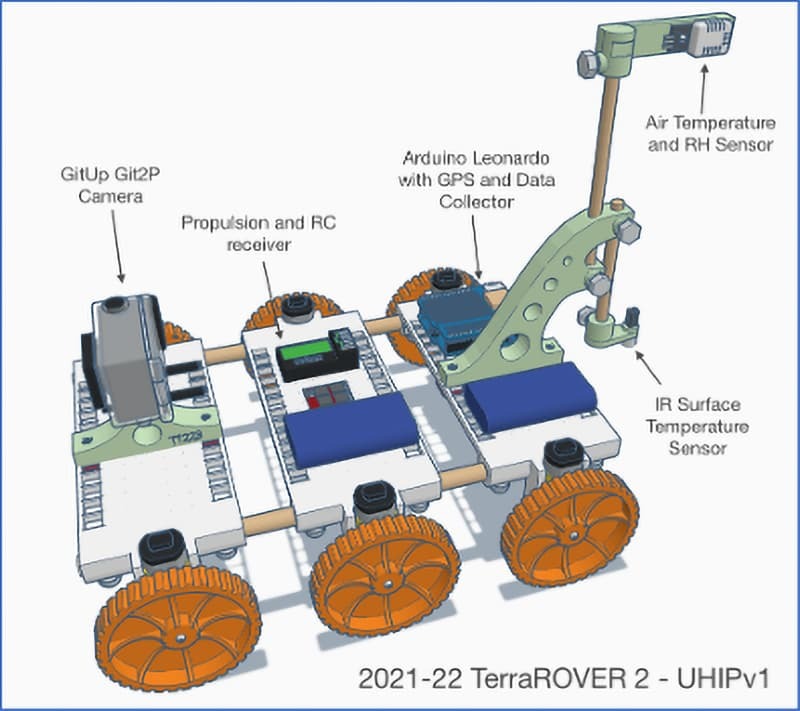
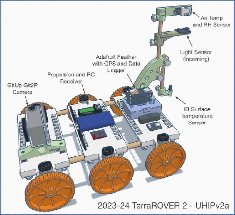
The AREN project developed the Urban Heat-island Instrumentation Package (UHIP) to be used for studying the variability of absorption and reflection of incoming solar radiation by different land-surface materials. All production versions of the UHIP (2021-2025) include a thermal infrared surface temperature sensor, an air temperature and relative humidity sensor, and a GPS receiver. These are integrated into an Arduino-based controller and data collector. The 2023-24 model included a light sensor for detecting incoming solar radiation, and the 2025 version includes a second light sensor pointed at the surface to collect reflectance values. The UHIP collects a datapoint every 2-3 seconds, and the data sets can be processed in a variety of tools, including spreadsheet programs, CODAP, and geographic information systems (GIS).
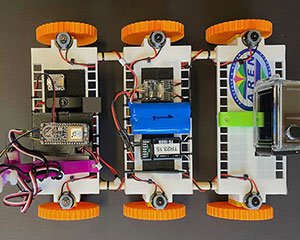
TerraROVER and UHIP Production Models used in the AREN Project:
TerraROVER 2021-2022 Features:
- 3D printed wheels, decks, and sensor mounts
- Arduino Leonardo-based UHIP sensor package
- GPS
- Infrared surface temperature sensor
- Air temperature and relative humidity sensor
- GitUp Git2P Camera
TerraROVER 2023-2024 Features:
- 3D printed wheels, decks, and sensor mounts
- Adafruit Feather-based UHIP sensor package
- GPS
- Infrared surface temperature sensor
- Air temperature and relative humidity sensor
- Light sensor (incoming)
- GitUp Git2P Camera
TerraROVER 2025 Features:
- Commercially produce rubber wheels,
- Commercially manufactured decks,
- 3D printed sensor mounts
- Adafruit Feather-based UHIP sensor package
- GPS
- Infrared surface temperature sensor
- Air temperature and relative humidity sensor
- Dual-light sensors (incoming and reflected light)
- AKASO v50 X Camera
Additional instrumentation is in development with added capabilities, such as thermal imaging, ground-level aerosols (PM2.5) and CO2 monitoring, and more. Users of TerraROVERs are encouraged to develop their own instrument packages to suit their research needs as well.
The AREN Project trains participants to both operate the TerraROVER and to process and analyze the data it collects. A variety of data analysis tools are employed to address a wide range of skill levels from upper elementary through university-level research.
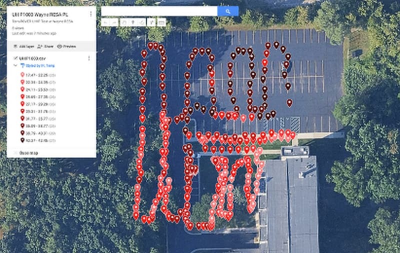
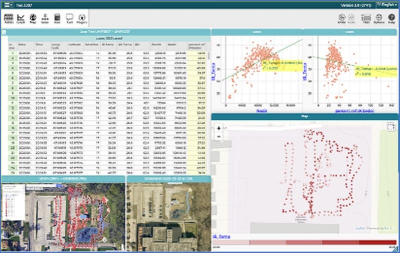
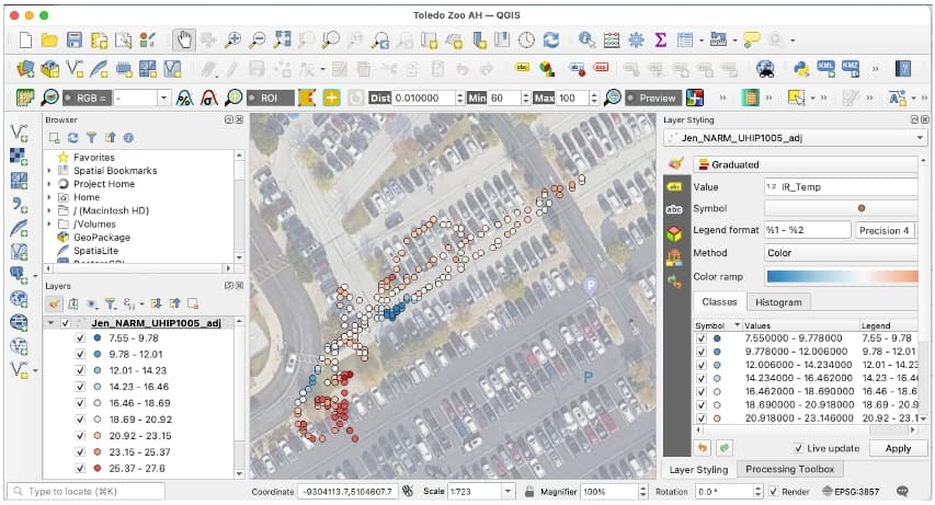
Examples of TerraROVER Data
Examples of data products
UHIP Surface Temperature Data Plot: Google My Maps
UHIP Data Plot Analysis and Mapping: CODAP
UHIP Surface Temperature Plot: QGIS
Interpolated Surface Temperature: ArcGIS Online
AquaROVERs
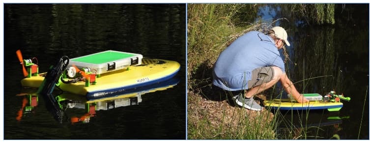
AquaROVER
AquaROVER: A NASA-designed remote-controlled aquatic craft for collecting remote water quality measurements. The AquaROVER includes a Vernier Instruments data acquisition package for collecting measurements of various water quality parameters.
AquaROVER version 7.2 Deployment
The AquaROVER Platform was deployed in a limited number of settings. Due to supply chain issues and the complexity of the system, AquaROVER was never brought to scale during the project. It continues to be used for water quality evaluation in select settings, but there is no plan to resume production at this time.
Please note: The AquaROVER is a patented NASA technology (US-Patent-10,059,418). A license is required to produce or use this platform. Patent information can be found here: https://ntrs.nasa.gov/citations/20180005310.
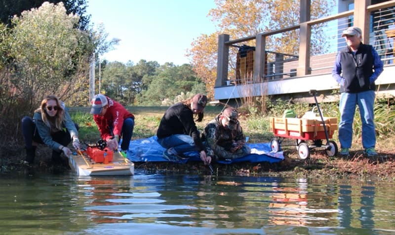
Students at Chesapeake Bay Environmental Center with AquaROVER 4 prototype
Examples of AquaROVER Data Products
AquaRORVER Example Dataset
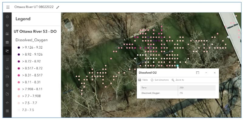
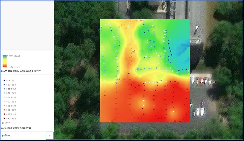
Dissolved Oxygen Plot on Ottawa River, Toledo, OH with AquaROVER data and ArcGIS Online
AREN Science
NASA Remote Sensing
Overview
NASA is famous for sending astronauts, probes and telescopes into space to study the solar system and the cosmos. Less widely known is the fact that NASA helps scientists study the Earth as well, using:
- Remote Sensing satellites and aircraft, and
- In situ measurements – such as Atmospheric Sounding using rockets and instrumented aircraft, balloons, and drones.
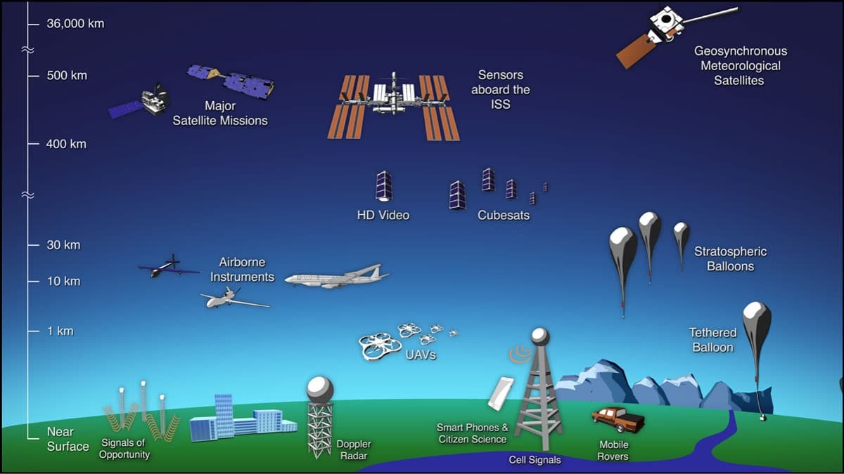
Nasa Remote sensing platforms. Image credit: NASA Scientific Visualization Studio
In fact, NASA has an entire fleet of Earth Observing Satellites (EOS) that observe a wide range of phenomena on Earth, including the atmosphere, oceans, and land. These satellites help scientists study the Earth on a global scale.
Remote Sensing
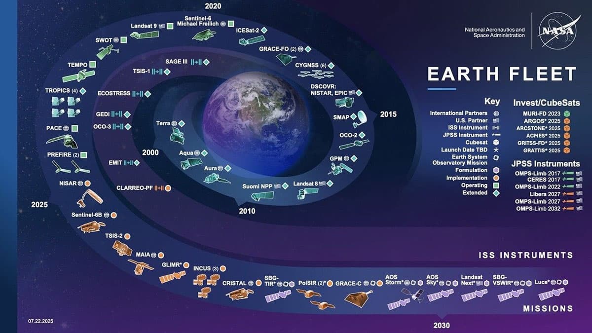
NASA Earth Observing Satellite Fleet. Image credit: NASA Scientific Visualization Studio
Remote Sensing is the process of studying objects or phenomena from a distance using sensors, without direct contact. By analyzing how different surfaces absorb and reflect energy across the electromagnetic spectrum, remote sensing helps us understand Earth’s environment, weather patterns, and more.
- Passive Remote Sensing uses sensors to detect light or energy emitted or reflected from an external source, such as the sun. A camera is a common example—it captures light reflected from surfaces without touching them. Satellite systems like Landsat also use passive remote sensing to monitor Earth’s surface.
- Active Remote Sensing, on the other hand, involves sensors that emit their own signal toward the target and measure the reflection. Technologies like Radar and LiDAR are examples of active remote sensing and can be used for mapping terrain and elevation, measuring water content of clouds and wind speed in storms, measuring how much moisture is in the soil, and more.
In situ measurement means studying atmospheric conditions and other phenomena through direct contact. NASA uses sensor-equipped rockets, aircraft, and balloons to travel through the atmosphere and collect data on its composition and wind speed. This process, called Atmospheric Sounding, helps scientists understand the chemical makeup of the atmosphere and its dynamic behavior—critical for weather forecasting and climate research.
Aeropods
The AREN Project introduces learners to remote sensing and in situ data collection using Aeropods and ROVERs—tools that study many of the same phenomena as NASA’s Earth-observing satellites, but at a local scale. While satellite data provides the big-picture view of Earth systems, Aeropods and ROVERs allow us to explore these phenomena up close. This local perspective helps reveal variability within large satellite pixels and offers a hands-on, place-based experience in collecting and analyzing environmental data.
Aeropods can carry cameras that capture visible, near-infrared, and thermal-infrared imagery for remote sensing. They can also carry in situ sensors to directly measure:
- Air temperature
- Relative humidity
- Barometric pressure
- Wind speed
- Atmospheric particles (aerosols) and gases
Greenleaf Index (isolating vegetation) created with imagery captured with a MonoCam Aeropod
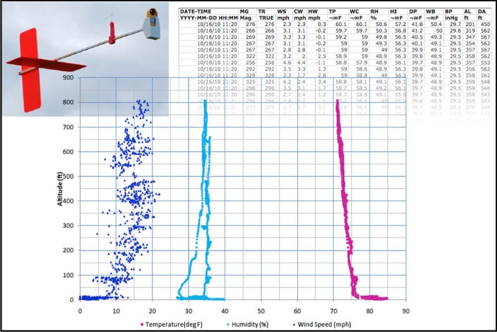
Profiler Aeropod data showing variability in boundary layer temperature, wind speed, and humidity with altitude
TerraROVERs
TerraROVERs
The TerraROVER with UHIP sensor package combines both in situ and remote sensing capabilities:
- In situ sensorsmeasure:
- Air temperature
- Relative humidity
- Remote sensorsinclude:
- A thermal infrared sensor for detecting surface temperature
- Light sensors for measuring incoming and reflected solar radiation
These measurements help scientists and learners understand how different surface materials interact with solar radiation, influencing atmospheric heating. This research sheds light on important phenomena such as the urban heat-island effect, energy balance, and climate variability.
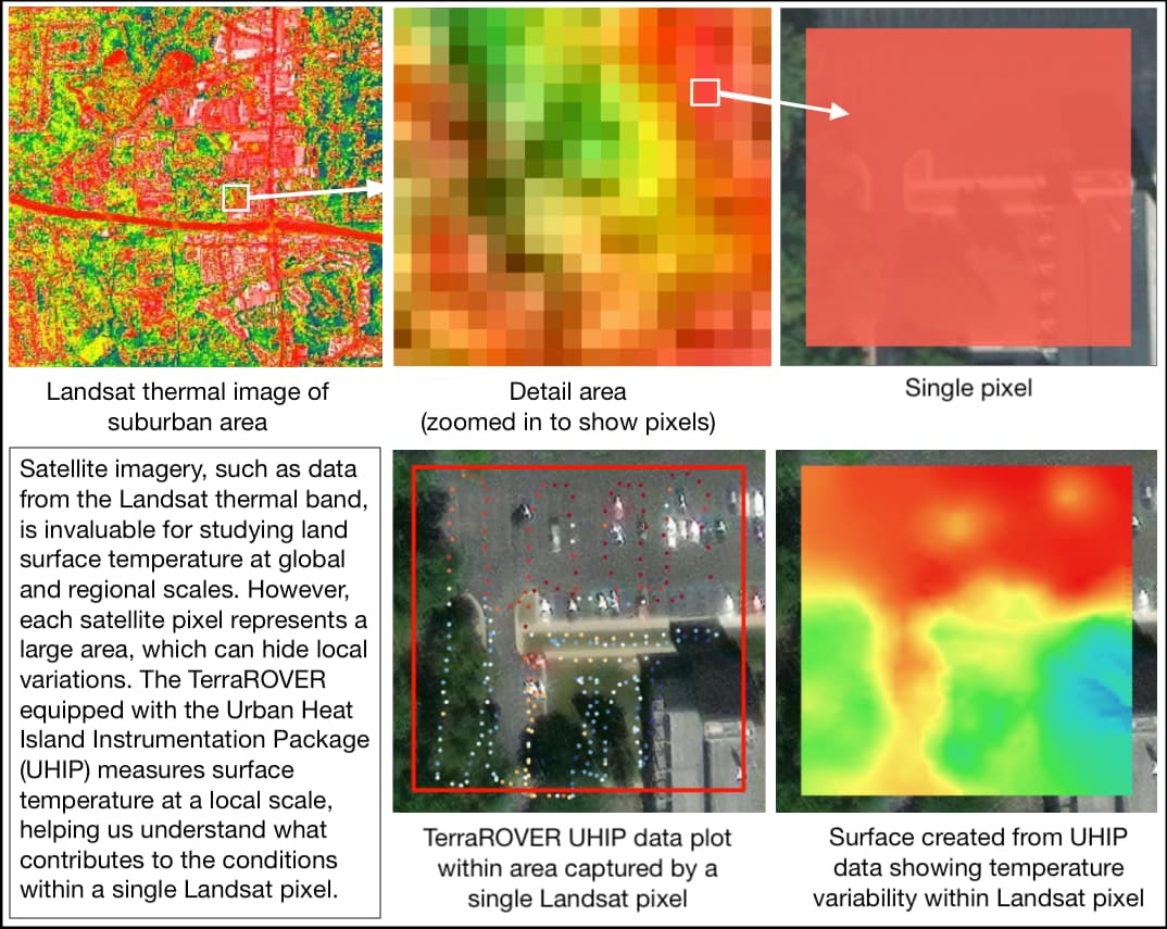
Comparison of satellite (global and regional scale) and TerraROVER (local scale) measurements of surface temperature
AquaROVERs
AquaROVERs
The AquaROVER carries a set of Vernier instruments that measure water quality variables in situ. As it moves across a water body, it directly samples:
- Water temperature
- Dissolved oxygen
- pH
- Conductivity
- Nitrate levels
These measurements help scientists and learners monitor water quality and understand how conditions vary within aquatic environments—critical for studying ecosystems and detecting pollution.
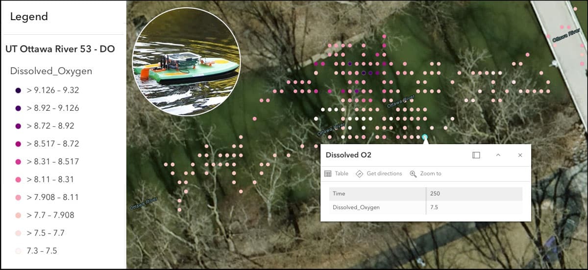
AquaROVER data showing dissolved oxygen levels in Ottawa River, Toledo Ohio
The AREN Project gives learners hands-on experience with Remote Sensing and in situ data collection using tools like Aeropods and ROVERs. Participants not only collect environmental data but also learn how to analyze and interpret it—building skills that connect science concepts to real-world applications.
Educational Activities Archives
 TerraROVER UHIP Environmental Design Challenge
 Student teams build their knowledge and engage in hands-on exploration of the Urban Heat Island Phenomenon (UHIP) from a local perspective using AREN TerraROVER technology. By analyzing environmental data and applying engineering design thinking, students apply their knowledge through an engineering design challenge to create a concept map for a UHIP‑resilient neighborhood.
 AREN March Winds Activity
 AREN Wind Stick activity participants will make an AREN Wind Stick and then use it to record observations of Wind Strength, for the month of March. This tool can be used to help determine whether the proverb, “March winds roar in like a lion and goes out like a lamb,” is true at their location for the current year. Participants will also be introduced to the science of why March Winds are generally different at the beginning and end of the month.
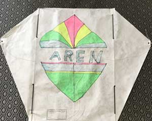 Building and Flying Frustrationless Flyer Sled Kites
 Activity participants, age nine and above will enjoy following step-by- step presentation directions to build and decorate their own “Frustrationless Flyer” Sled Kite ready for field flights and to take home.
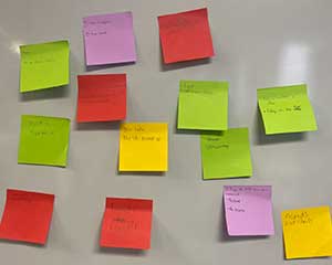 My Place on Earth
 This activity can be combined with one or more other AREN activities and will help students understand why NASA studies the Earth and how we can see Earth from above, then prompts students to use sticky notes and instructor-led discussion to consider what is special about “their place” and how seeing the local area from above could help solve an environmental problem.
 Kite Mysteries
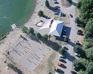
 Learners will be prompted to answer questions (framed as “mysteries”) about aerial images taken from a camera mounted on a kite. This short activity can be a good lead-in to other kite-based activities or lessons like land cover analysis.
 Exploring Surface Winds Using Mini-Kites
 Students will make a mini-kite with a string length of less than a meter. Students will fly a kite to explore local surface winds.