Concepts and Phenomenon
Atmospheric Structure and Trends
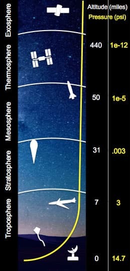
The Earth’s atmosphere is a thin layer of air that extends from the Earth's surface to the edge of space. The Earth is a sphere with a diameter of approximately 8000 miles; the thickness of the atmosphere is about 60 miles. If the Earth were the size of a basketball, the thickness of the atmosphere could be modeled by a thin sheet of plastic wrapped around the ball!
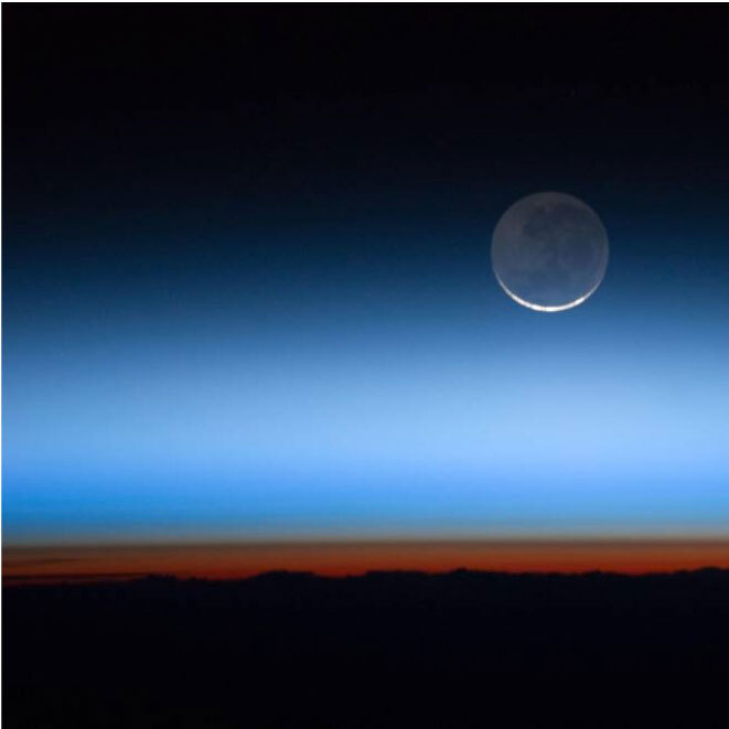
The atmosphere is divided into distinct layers. The image below captures the Thermosphere as an orange-red band over the Earth and the Stratosphere and beyond as a progression of orange to blue. The most relevant layer is the Troposphere because it is the layer closest to the Earth and contains breathable oxygen. However, the outer layers of the atmosphere are essential for other reasons. The Stratosphere houses the ozone layer, which blocks the more dangerous UV-B and UV-C radiation from the sun from reaching the Earth. The Mesosphere protects the Earth by burning up small objects and meteors before they can impact Earth’s surface. Similar to the Stratosphere, the Thermosphere and Ionosphere absorb harmful solar radiation like X-rays. Certain portions of the Ionosphere can also bounce radio waves back down to the Earth, allowing for long-distance radio transmissions.
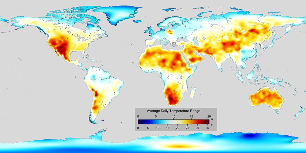
In addition to being closest to the Earth’s surface, the Troposphere is where weather occurs. The unequal heating of the Earth’s surface drives air and ocean circulation and causes the climate to vary by latitude. Air and water circulation is initiated at the equator, where insolation is most significant—masses of air and ocean transport heat energy from areas of high concentration to low concentration. The movement of these masses of air and ocean establishes an equilibrium state of heat distribution, which determines the general climate bands, or zones, that we observe at different latitudes.
Atmospheric properties are not uniform; fluid properties are constantly changing with time and location. We call this change the weather. The atmosphere’s properties and the weather it generates affect all parts of the Earth; these interactions characterize the Earth system. The Earth system behaves as a single, self-regulating closed system comprising physical, chemical, biological, and human components.
Currently, much of what is known about atmospheric science is derived from larger-scale models and trends, which are primarily conducted on airplanes traveling at hundreds of miles per hour. Due to the imprecise collection method, the science, to some degree, is aggregated and generalized, missing the finer details. The goal of the AREOKATS program is to study the troposphere on a smaller scale to understand localized trends in climate and weather better.
In-situ measurements
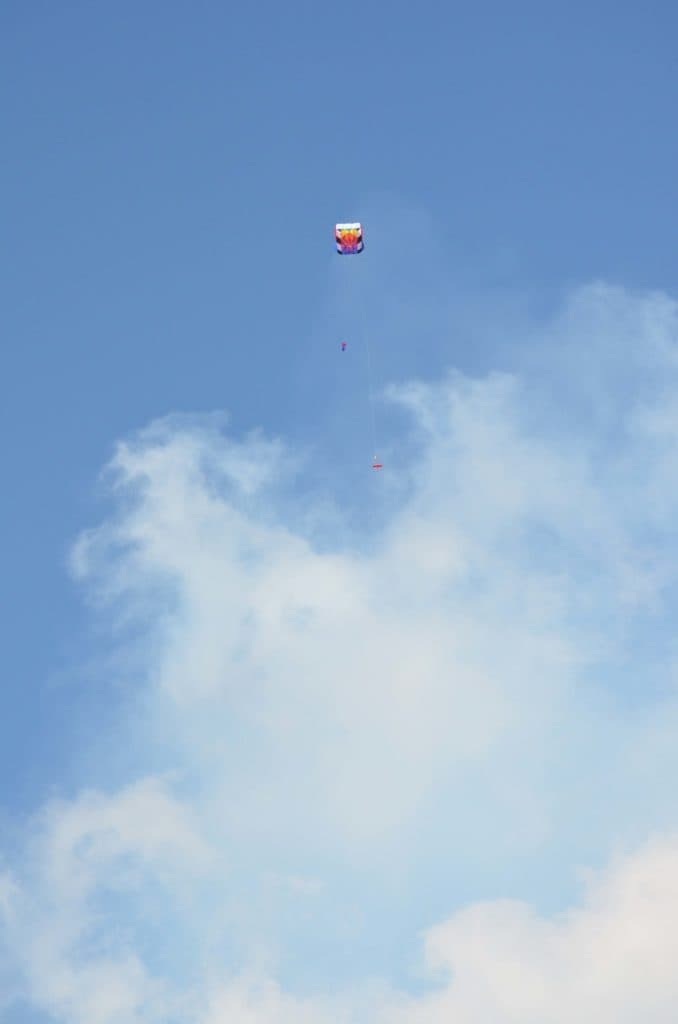
In-situ measurements are those taken within the environment being studied, in contrast to remote sensing data, which gather information about the object of research from a distance. Within atmospheric sciences, in situ measurements can be taken with towers, tethered balloons, and surface-level platforms. The AEROKATS Profiler enables in-situ measurements at higher altitudes than traditional in-situ platforms. For example, it’s possible to capture data about wind speed, temperature, humidity, and a variety of other readings from hundreds of feet in the atmosphere. In-situ data collection offers a more localized perspective on the weather patterns and phenomena described in this section.
Atmospheric Sounding
Aerosols are minute particles suspended in the atmosphere. When these particles are sufficiently large, we notice their presence as they scatter and absorb sunlight. Their scattering of the sun can reduce visibility (haze) and redden sunrises and sunsets. Aerosols interact both directly and indirectly with the Earth’s radiation budget and climate. As a direct effect, the aerosols scatter sunlight directly back into space. As an indirect effect, aerosols in the lower atmosphere can modify the size of cloud particles, changing how the clouds reflect and absorb sunlight, thereby affecting the Earth’s energy budget.
Aerosols can also serve as sites for chemical reactions to occur (heterogeneous chemistry). The most significant of these reactions is the one that leads to the destruction of stratospheric ozone. During winter in the polar regions, aerosols grow to form polar stratospheric clouds. The large surface areas of these cloud particles provide sites for chemical reactions to take place. These reactions lead to the formation of large amounts of reactive chlorine, ultimately resulting in the destruction of ozone in the stratosphere. Evidence now exists that shows similar changes in stratospheric ozone concentrations occur after significant volcanic eruptions, like Mt. Pinatubo in 1991, where tons of volcanic aerosols are blown into the atmosphere.
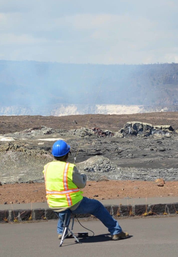
The following images are from the Verex mission over the Big Island, HI, where SO2 and CO2 sensors were flown using kites near volcanic craters to measure aerosol levels and validate current volcano models.
Three types of aerosols significantly affect the Earth’s climate. The first is the volcanic aerosol layer, which forms in the stratosphere following significant volcanic eruptions, such as Mt. Pinatubo. Winds in the stratosphere spread the aerosols until they practically cover the globe. Once formed, these aerosols stay in the stratosphere for about two years. They reflect sunlight, reducing the amount of energy reaching the lower atmosphere and the Earth’s surface, cooling them.
The second type of aerosol that may have a significant effect on climate is desert dust. Pictures from weather satellites often reveal dust veils streaming out over the Atlantic Ocean from the deserts of North Africa. Because the dust is composed of minerals, the particles absorb sunlight as well as scatter it. Through the absorption of the sun, the dust particles warm the layer of the atmosphere where they reside. This warmer air is believed to inhibit the formation of storm clouds. Through the suppression of storm clouds and their consequent rain, the dust veil is thought to further desert expansion.
The third type of aerosol comes from human activities. While a significant fraction of human-made aerosols comes in the form of smoke from burning tropical forests, the primary component is sulfate aerosols created by the burning of coal and oil. The concentration of human-made sulfate aerosols in the atmosphere has grown rapidly since the start of the Industrial Revolution. The sulfate aerosols absorb no sunlight, but they reflect it, thereby reducing the amount of sunlight reaching the Earth’s surface. Sulfate aerosols are believed to survive in the atmosphere for about 3-5 days. The sulfate aerosols also enter clouds, where they cause the number of cloud droplets to increase but decrease the droplet sizes. The net effect is to cause the clouds to reflect more sunlight than they would without the presence of sulfate aerosols.
Particles
Particles and aerosols are closely related. Particles are microscopic solid or liquid matter in the Earth’s atmosphere, and aerosols, in contrast, are a mixture of particulate matter and air. Particles are most often differentiated by size, where smaller sizes are more harmful to humans. Most notably, PM10 and PM2.5 are specific size classes of particulate matter, with PM10 being between 10 and 2.5 micrometers in diameter and PM2.5 being 2.5 micrometers or less in diameter. Particles are considered a carcinogen and the deadliest pollution because they can enter a person’s lungs and blood and cause gene mutation, respiratory issues, and cardiovascular issues. The American Heart Association estimates that in the United States alone, PM2.5 air pollution causes approximately 60,000 deaths annually.
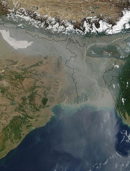
Even if the air looks clear, it’s nearly certain you’ve inhaled millions of PM2.5 particles. Though often invisible to humans, such particles are present everywhere in Earth’s atmosphere, and they come from both natural and human sources. Wind, for example, lifts large amounts of mineral dust aloft in the Arabian and Saharan deserts. In many heavily urbanized areas, such as eastern China and northern India, power plants and factories that burn coal often lack filters, producing a steady stream of sulfate and soot particles. Motor vehicle exhaust also generates substantial amounts of nitrates and other particulates. Both agricultural burning and diesel engines produce dark, sooty particles, which scientists refer to as black carbon.
Although PM2.5, as a class of particle, clearly poses health problems, researchers have had less success assigning blame to specific types of particles. One of the major sticking points is that PM2.5 particles frequently mix and form hybrid particles, making it challenging for both satellite and ground-based instruments to distinguish the individual effects of these particles.
Seabreeze
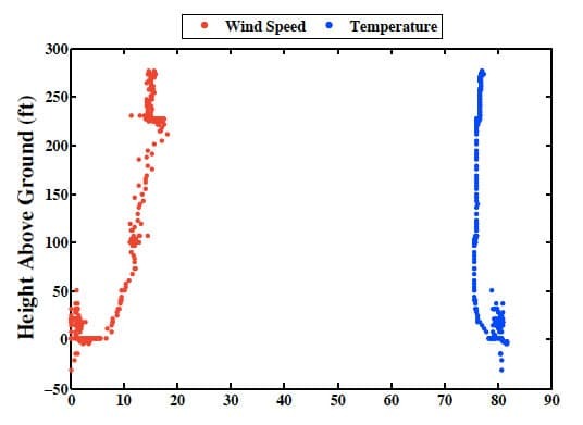
The sea breeze is a very localized phenomenon where the cooler, high-pressure air over the ocean moves inland towards the warmer, low-pressure air over the land, creating convection. The movement of air causes a breeze coming off the water. Convection is reversed at night when the sun goes down; the land becomes cooler than the water, and the high-pressure air over the land moves toward the low-pressure air over the ocean. The sea breeze also only occurs a small distance inland and up into the atmosphere. The following plot, derived from data gathered using a Profiler, shows both temperature and wind speed in relation to altitude. Once above ground level, wind speeds gradually increase, while the temperature drops and then remains relatively constant. At around 230 feet, however, the temperature increases and the wind speed drops dramatically. The sudden change is due to the Profiler reaching the top of the sea breeze, where the wind drops off and the temperature increases because the colder wind off the water is gone.
Boundary Layer
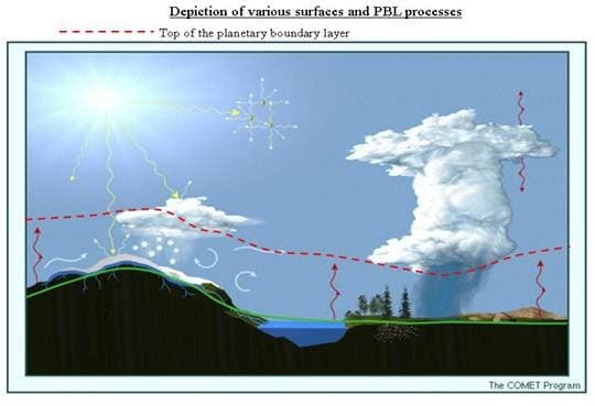 A boundary layer, in broad terms, is the layer of fluid in the immediate vicinity of a boundary where the effects of viscosity are significant. In atmospheric sciences, the boundary layer is the layer closest to the Earth's surface that is influenced by the surface itself. The atmospheric boundary layer, or ABL, is highly variable in both turbulence and height; it’s deeper over the desert and shallower over the ocean, as well as deeper during daylight hours. During the day, the heat rising from the Earth’s surface creates convection; the warmer the surface temperature, the taller the convection. The ABL's sensitivity to surface temperature is also why the convection is deeper over desert regions.
In contrast, the addition of moisture to the convection either through evaporation or other means leads to a decrease in the height of the layer. Surface features have a significant influence on the winds within the ABL. When mountains or a building obstruct the wind, it introduces random vertical and horizontal velocities that interrupt the constant flow and create turbulence. Areas with a high density of man-made structures can experience significantly lower wind speeds compared to open areas over land and ocean.
Just above the ABL is a layer of warm air known as a temperature inversion. The temperature conversion is unusual because typically, as altitude increases, temperature drops; however, the temperature conversion is a region higher in altitude and warmer than the ABL. The boundary of warmer air is essential in cloud formation and precipitation, as well as the diffusion of air pollutants. Beyond the ABL and temperature inversion, the atmosphere is free from friction, and the wind patterns change. At higher altitudes, the wind speed increases, the wind direction changes, and the wind becomes geostrophic, meaning it flows from areas of high pressure to low pressure.
Lapse Rate
The lapse rate is the rate of change in temperature with altitude and is highly variable due to the influences of radiation, convection, and condensation. Lapse rate is considered positive when the temperature decreases with altitude, zero when the temperature remains constant, and negative when the temperature increases with altitude. There are different types of lapse rates. The adiabatic lapse rate refers to the temperature change that occurs due to the rising or sinking of air, rather than due to heat loss or gain from the surrounding environment. Adiabatic lapse rate can be either dry or moist. Dry adiabatic lapse rate is determined entirely by the specific heat capacity of the air at constant pressure. The wet adiabatic lapse rate is involved when the air has moisture that condenses. The process of condensation allows the air to retain heat longer and cool more slowly than if it were dry. The moist adiabatic lapse rate is more varied because of the variability of a region's moisture levels. The moist air can give off enough condensation in time to become dry.
The differences between the typical lapse rate and the dry and moist adiabatic lapse rates have a significant influence on the vertical stability of the atmosphere. In other words, it determines whether a parcel of air is resistant to outside forces or if it will move from its original position. This property is essential for meteorologists in forecasting cloud formation, thunderstorms, and turbulence. The rate provides information as to how far a parcel of air will rise and whether it will carry water vapor high enough to form clouds, even higher to form precipitation, or high still to form thunderclouds.
Diurnal Cycle
All the forces outlined above are on a diurnal cycle, meaning they are on a 24 hour schedule. The driving force behind the diurnal cycle is the sun and its absence, as well as the heat it provides to the Earth. The most commonly studied cycle is the temperature change. The Earth's surface, like any other surface, has a specific capacity to absorb heat. As the sun rises and shines light on the Earth's surface, it slowly begins to retain heat and radiate it to the air nearest the surface. So even though the sun is directly overhead and emitting maximum power at noon, the temperature isn’t at the daily peak until afternoon when the heat from the earth’s surface transfers to the air.
Other meteorological factors follow a diurnal cycle. Opposite temperature, humidity is lowest in the afternoon and highest before sunrise. Winds and clouds are also on diurnal cycles. Winds tend to increase during the day and change direction in a clockwise rotation, and decrease at night and reverse rotation. Similarly, clouds and precipitation tend to increase in the afternoon and decrease at night, however, the opposite is true over the large bodies of water.
All the forces outlined above operate on a diurnal cycle, meaning they follow a 24-hour schedule. The driving force behind the diurnal cycle is the sun and its absence, as well as the heat it provides to the Earth. The most commonly studied cycle is the temperature change. The Earth's surface, like any other surface, has a specific capacity to absorb heat. As the sun rises and shines light on the Earth's surface, it slowly begins to retain heat and radiate it to the air nearest the surface. So even though the sun is directly overhead and emitting maximum power at noon, the temperature isn’t at the daily peak until the afternoon when the heat from the earth’s surface transfers to the air.
Other meteorological factors follow a diurnal cycle. Opposite temperature, humidity is lowest in the afternoon and highest before sunrise. Winds and clouds are also on diurnal cycles. Winds tend to increase during the day and change direction in a clockwise rotation, and decrease at night, reversing their rotation. Similarly, clouds and precipitation tend to increase in the afternoon and decrease at night; however, the opposite is true over the large bodies of water.
All the forces outlined above operate on a diurnal cycle, meaning they follow a 24-hour schedule. The driving force behind the diurnal cycle is the sun and its absence, as well as the heat it provides to the Earth. The most commonly studied cycle is the temperature change. The Earth's surface, like any other surface, has a specific capacity to absorb heat. As the sun rises and shines light on the Earth's surface, it slowly begins to retain heat and radiate it to the air nearest the surface. So even though the sun is directly overhead and emitting maximum power at noon, the temperature isn’t at the daily peak until afternoon when the heat from the earth’s surface transfers to the air.
Other meteorological factors follow a diurnal cycle. Opposite temperature, humidity is lowest in the afternoon and highest before sunrise. Winds and clouds are also on diurnal cycles. Winds tend to increase during the day and change direction in a clockwise rotation, and decrease at night, reversing their rotation. Similarly, clouds and precipitation tend to increase in the afternoon and decrease at night; however, this is not the case over large bodies of water.