Overview:
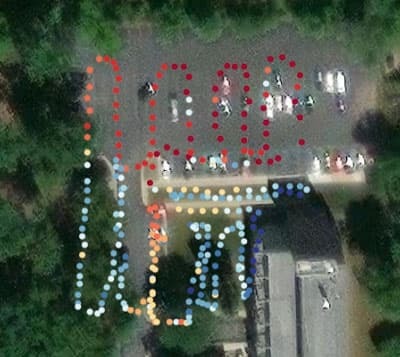
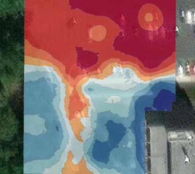
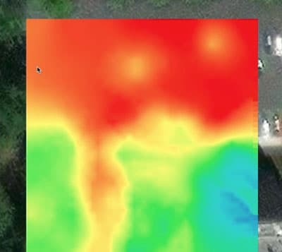
In this exercise we will take a dataset collected with an AREN TerraROVER and UHIP, and import it into ArcGIS Online. ArcGIS Online is a web-based Geographic Information System (GIS) application that allows you to process and analyze spatial datasets both on their own, and in relation to other spatial datasets through the use of layers. The tutorial walks you through plotting and symbolizing your data, then creating both vector and raster based surfaces with the data.
Links to photo(s) and videos that demonstrate the activity:
 |  |  |
Technology required: Computer with internet access, ArcGIS Online Educational Account (free), Spreadsheet software (MS Excel, Google Sheets, Apple Numbers, or LibreOffice Calc), Data collected with a TerraROVER and Urban Heat Island Instrumentation Package (UHIP).
Setting: Classroom, Indoor
Resources Included for this Learning Activity: Tutorial Video
Lesson Duration: [1 - 2 class periods]
Participant Group Size: [N/A]
Analysis Type: descriptive, quantitative, GIS
History of development and implementation of this learning activity: N/A
NGSS Science Standards: There are no direct NGSS standards for GIS. Instead, GIS helps to address the standards in the following areas:
Science and Engineering Practices (SEPs): GIS is a powerful tool for developing skills such as:
Analyzing and Interpreting Data: Students can use GIS to analyze spatial data, such as population density or climate patterns, to identify trends and patterns.
Developing and Using Models: GIS allows students to create and manipulate digital models of geographic phenomena, helping them visualize and understand complex systems.
Using Mathematics and Computational Thinking: GIS involves various mathematical calculations and spatial analysis techniques, directly supporting this SEP.
Disciplinary Core Ideas (DCIs): GIS can be used to teach concepts in various Earth and Space Science (ESS) DCIs, such as:
Earth Systems: Analyzing maps to understand Earth's surface features or patterns of weather.
Earth and Human Activity: Examining how human activities, like urbanization or deforestation, impact the environment on a geographic scale.
Crosscutting Concepts (CCCs): GIS is particularly useful for illustrating CCCs like:
Patterns: Identifying spatial patterns in data to understand natural processes.
Cause and Effect: Exploring how different factors, when viewed geographically, influence outcomes.
Systems and System Models: Creating and analyzing geographic models to understand how different parts of Earth's systems interact.